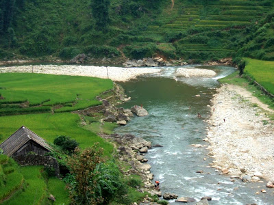

Muong Hoa Valley, being part of Mt. Fansipan's varied topography is at the lowest altitude of about 1000 meter. It was formed by a narrow strip of land at the base on east side of the mountain for a length of 30km. It lies between two high ranges of mountains running parallel southeast of Sapa Town. The valley is the home for H'mong, Zao, Zay minority groups, who have been working on the slopping land and living their own ways for hundreds over years.


Muong Hoa Valley is just 8km away from Sapa Town but it takes about 5 hours to walk downhill, along the Muong Hoa River, through the terraced fields and passing some hamlets of minority groups such as H'Mong, Ylinh Ho and Lao Chai.


Muong Hoa Valley is the largest farmland for rice growing in Sapa District, covering a land of 10sq.km.


Muong Hoa Valley, famous for its breathtaking scenery, is the most beautiful valley in the region.


Different shade of green before harvest.


Absolutely stunning landscapes, the color, the pattern, they are just sublime and majestic.


The vally starts as a small steam of water from the foot of Silver Waterfall about 14km north west of Sapa town weaving its way along mountain's feet southeastwards between the two ranges.


Rain water running down from highest elevation of mountain ranges, gathered into dozens of streams flowing downhill to form Muong Hoa River.


Muong Hoa River peacefully flows through the valley, weaving itself along the foots of mountains, nourishing the earth and the people.


Water is in abundance in the valley and the water scenery makes visitors suffocated.


Resting time for buffaloes to enjoy in the cooling water after quite some time of hard work.


The geese, the ducks are enjoying their time as well in the natural water pond. While the westerner had fun in a tradition stone rice grinder.


These are "Guides" who bring the tourists into the valley. They are not actually professional guides but they know the roads well.


No comments:
Post a Comment